Little Grider Fire Update

By Linda Martin

I haven’t received any new official Forest Service news updates about the fire, so I’ll share with you what I’ve heard. So far the only evacuations that have taken place are those along Elk Creek Road, south of town. Residents living past Five Mile Bridge have been asked to leave voluntarily. The Titus Fire is heading east toward Elk Creek. Miners and campers have been forced to leave the area, and access to Norcross Campground is no longer allowed.

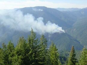
Meanwhile the Little Grider Fire in the hills west of Happy Camp continues to grow. At this point hundreds of fire fighters have been redirected from other areas in our forest and are now gathered here to help save the town of Happy Camp from incineration. The fire is moving toward Buckhorn Road, and the residents in the Live Oak area may be asked to evacuate within the next 24 hours. This will impact approximately thirty families. An old logging road in that area is being widened and fires are being set to burn out brush in the area, in hopes of slowing the Little Grider Fire as it heads toward this populated area on the west side of Indian Creek. Smoke coming from the top of the hill above the airport is most likely being intentionally set by fire fighters.

Smoke conditions this morning were not favorable for flying, but helicopters are now dropping water on the fire, including a Sky Crane Tanker with 2500-gallon capacity, a CH53 Super Stallion Tanker, and at least three other smaller capacity helicopters with 100 to 250-gallon buckets. Fixed wing aircraft with fire retardant are not being used, most likely because of the terrain being unsafe for them.

The Forest Service is posting updates online at Elk Complex Updates. According to the most recent update the Little Grider Fire covers about 636 acres, and continues to burn downhill towards Perkins Gulch. The Titus Fire covers approximately 1408 acres. It burned over Titus Peak towards Elk Creek yesterday and lines have been constructed around homes in the area.

Long time residents of Happy Camp are not worried. They remember the fires of 1987 when flames threatened the town from Slater Ridge and evacuations were considered. The people I’ve talked to who have been here long enough to remember that fire, twenty years ago, believe that the fire fighters are competent and able to save their homes. I hear this even from people whose homes seem to be in the path of the fire. Others who haven’t experienced fires so close to their homes seem far more concerned.

Forest Fires Near Happy Camp May Force Evacuations Sunday and Monday

By Linda Martin

A new forest fire burning in the hills north and east of the Happy Camp airport may force evacuations of homes around the airport and in Indian Meadows by midday Sunday or Monday morning. More information will be posted as it becomes available if possible. My home is one of those that may have to be evacuated unless the fire is brought under control.

According to a local deputy, bulldozers may be used to widen a forest road behind the airport in an attempt to stop the fire from proceeding into Happy Camp through the area around the airport.

Another fire is burning in the hills south of Elk Creek on the south side of the Klamath River. This fire can be clearly seen from Highway 96, and may threaten homes along Curly Jack Road.

Update, 9:04am – The fire is heading toward Happy Camp. Fire fighters are mapping out home locations in order to provide protection should the fire get close to them. A town meeting will be held at 11am at the Happy Camp Grange Hall to discuss evacuations.

John Evans
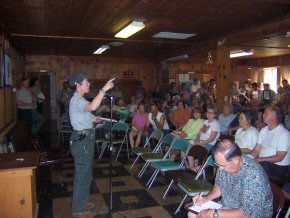
Happy Camp deputy John Evans announced evacuation plans at a meeting on Sunday. You can click on this picture for a full size photograph on which the fire maps can be clearly seen.

Update, 11:51am -  I attended the meeting at the Grange. This was one of the best attended community meetings, ever. The place was packed. Valery Lambeth, Plans Section Chief, was MC. The fire above the airport is being called the Little Grider Fire. Rob Rowley, a corporal from the Sheriff’s Department in Yreka is here to help with evacuations. He will work with the Office of Emergency Services after the fire to help with any needed reimbursements.

Marcia Armstrong, our County Supervisor, attended and spoke to us of her support for this town in this time of crisis. Next up was Alan Vandiver, Happy Camp District Ranger. He told us he has over thirty years working with forest fires and gave us confidence that there’s a competent and effective fire fighting team working on controlling this fire.

Kent Swartzlander is the Incident Commander. He provided an overview of the fires currently burning around Happy Camp, including the Little Grider Fire, which is threatening our community.

Local Sheriff’s Dept. Sergeant, John Evans, was next to speak. He told us that evacuations, if needed, will take place from Doolittle Bridge on Indian Creek, all the way south through town to Chambers Flat on Highway 96. He said that if you leave your home you should put a note on the door telling where you’ve gone. That way deputies won’t waste time looking for people who are not on the premises.

Evacuees are requested to drive west from town as there are other fires near Highway 96, east of here. Sheltering for evacuated Happy Campers will take place at Marble Mountain Ranch near Somes Bar. There is limited room for livestock in that location, but it would be preferable for pet and livestock owners to find other accommodations for their animals if at all possible. It is not mandatory for evacuees to go to Marble Mountain Ranch – it is intended as shelter for people with no place else to go.

The area beyond Five Mile Bridge on Elk Creek Road is being evacuated at this time, however this is a conservative distance from fire danger, chosen because there’s a gate that’s easily closed. The residents between Five Mile Bridge and the Klamath River, including Curly Jack Road residents, are not considered at risk at this time though there are quite a few fires burning on that side of the river.

If you have any special needs, you are requested to write them out. A form we received at the meeting asks for your name, information about your special need, your address, your phone number, and your transportation requirements. This information must be taken to the Sheriff’s office in Happy Camp as soon as possible. Don’t wait until the last minute to ask for help.

John Evans stated that they are requesting that people be ready to evacuate within ten minutes, even if woken up at 3 in the morning by a uniformed deputy knocking on your door. The time to pack and get essentials together is now.

valery-lambeth.jpg
Valery Lambeth, Plans Section Chief, MC’d the meeting.rob-rowley.jpg
Rob Rowley of the Siskiyou County Sheriff’s Department is here to help coordinate evacuation efforts, if needed.

kent-swartzlander.jpg
Kent Swartzlander is Incident Commander for the Little Grider Fire.

alan-vandiver.jpg
Alan Vandiver, Happy Camp District Ranger, promised to answer every question before leaving the meeting. Here he is talking to Chris Sorenson, chairman of the Happy Camp Chamber of Commerce.

More Lightning Wednesday Evening in Siskiyou County

YREKA, CA—In Siskiyou County, more lightning occurred on Wednesday, July 11, as about 118 more down strikes hit the forest. Luckily, some rainfall came with this lightning storm. Overall, about 55 fires were started by storms this week, with approximately 32 of the fires active as of Thursday morning. The other 23 fires have been either contained or controlled. Most of the fires are less than 10 acres in size; however, some fires are just now being looked at due to their extremely remote and rugged locations.

As of Thursday, July 12th, the Klamath National Forest formed the Elk Complex in the Happy Camp Ranger District that has a number of the lightning-caused fires close to private property, as well as many others scattered throughout the district. A Type II Incident Management Team, with Kent Swartzlander as Incident Commander, is taking over management of the Elk Complex starting at 6:00 pm tonight. Three of the known fires within that complex are causing some concern (the Elk Fire, about 10 acres; the King Creek #2, about 40 acres; and the Tom Martin, about 10 acres). The Tom Martin Fire is about one and a half-miles south of the small town of Hamburg along Highway 96. No structures are threatened at this time, and an air tanker is being used to help the firefighters on the ground.

The Oak Knoll Ranger District has five confirmed fires, with three of them controlled. Of the two active fires, the China Fire is one mile north of China Peak, and is using an air tanker to help firefighters tackle this blaze. It is currently about 10 acres in size. Smoke from this fire may be seen from the Yreka and Fort Jones area, as well as from along Highway 96 near the town of Klamath River.

The Scott River Ranger District has seven fires in total, with five of them staffed at this time. Two of the fires are within or near the eastern edge of the Marble Mountain Wilderness. The Back and Sky Fires are about 10 and 25 acres in size, respectively. Heavy fuels and extensive mop-up are the concerns for these fires.

As of the morning of Thursday, July 12th, about 16 fires have been reported on the State Responsibility Areas protected by California Department of Forestry and Fire Protection (CAL FIRE); the largest is about 10 acres in size. All of these fires are contained.

The CAL FIRE information line is now available at (530) 842-2266. This number will have information on the fires managed by the Forest Service and CAL FIRE in the county, and will be updated as the situations change.

Lightning Sparks Fires in Siskiyou County

YREKA, CA—Lightning filled the sky over most of Siskiyou County on Tuesday, July 10, and employees of the California Department of Forestry and Fire Protection (CAL FIRE) and the Klamath National Forest (KNF) are busy working on the fires that started from over 1,200 down strikes from the storm.

As of the morning of Wednesday, July 11th, about nine fires have been reported on the State Responsibility Areas protected by CAL FIRE; the largest is about 10 acres in size. Six of these fires are contained. On the KNF-managed lands, about 30 fires have been reported, with most being less than one acre in size. There are about two fires over 20 acres in size. Many of the fires have firefighters walking in to staff the fires, and smoke jumpers have been ordered for the larger fires.

“It’s a dry year, and though we received rain on some of the forest, it wasn’t enough to stop any of the larger fires from spreading.” said Patty Grantham, Deputy Forest Supervisor for the KNF.

Reconnaissance flights are in progress this morning, and more fires may be found once the day warms. More lightning is predicted for today with increased precipitation.

As a reminder, CAL FIRE suspended dooryard burning permits as of July 1st. Though fire restrictions for the KNF are not in place yet, forest vegetation is very dry. All who are in the forest are asked to be extremely careful with fire.

The CAL FIRE information line is now available at (530) 842-2266. This number will have information on the fires managed by the Forest Service and CAL FIRE in the county, and will be updated as the situations change.

Source: Forest Service Press Release

Happy Camp Complex Forest Fire Update

Fire Retardant Drop

Fire retardant drop in the Happy Camp Complex fires. Photo by Ken Black of the Deadwood Strike

August 24, 2006, 11:00 am

From the Northern California Joint Incident Information Center

Current Situation: A weak low pressure trough over northern California will move east today and high pressure will build in behind it. Low humidity with gusty winds is expected. The air mass in northern California remains stable and dry with temperatures in the upper 80s and mid 90s.

Visitors need to be aware that there are numerous road, trail and area closures in place. Before heading out, please contact the local Forest Service Unit or log onto Inciweb.Org for additional information about fire-related restrictions and closures.

Air quality monitoring stations are in place. For additional information, please visit the following website: http://gacc.nifc.gov/oncc/predictive/weather/airquality.html.

No active Fire Weather Watches or Warnings are in effect today in Northern California.

The Joint Incident Information Center will no longer be staffed. However, the daily summary will continue to be updated and e-mailed to the current mailing list. Please visit Inciweb.Org for information related to all incidents and to obtain local contact information.

Northern California Region Active Totals

  • Major Incidents / Complexes: 4
  • Acres Burned: 54,448
  • Cost of active fires: $49,763,305
  • Personnel Committed: 1,328
  • Firefighter Injuries: 22
  • Fatalities (Aerial Firefighting Personnel): 2

Resources Committed

  • Engines: 16
  • Firefighting Crews: 29
  • Dozers: 3
  • Helicopters: 17
  • Overhead Personnel: 532

Between July 23rd and August 24th a total of 8 large fire incidents have occurred in the Northern California Region. Those large fires have burned more than 74,122 acres costing over $72,738,673 in suppression efforts.

INCIDENT SUMMARIES

Orleans Complex: Six Rivers National Forest; 15,710 acres; 70% Contained; Estimated Containment Date: 9/30/06; Total Personnel: 366; Cost to Date: $15M; Type 2 Incident Management Team (Sinclear) is assigned. Limited interior burning continues, primarily in the upper portions of Pearch Creek drainage. Firefighters continue to hold containment line on Highway 96 and Salmon River Road. Cultural resources remain threatened. A public meeting will be held tonight at 7p.m. at the Karuk Community Center in Orleans to introduce the incoming Incident Management Team. For more information on this fire, please visit http://inciweb.org/incident/370.

Bar Complex: Shasta-Trinity National Forest; 20,289 acres; 46% contained; Estimated Containment Date: 9/15/06; Total Personnel: 523; Cost to Date: $15M; A Type 1 Incident Management Team (Dietrich) is assigned. Fire continues to move easterly toward Limestone Ridge and south from Pony Butte/Salmon Mountain Ridge. Residence and historic mining sites continue to be threatened. Heavy smoke remains over the communities in and around Weaverville and as far away east as Redding. For more information, please visit http://inciweb.org/incident/357/

Uncles Complex: Klamath National Forest; 14,631 acres; 35% contained; Estimated Containment Date: 10/3/06; Total Personnel: 106; Cost to Date: $9M; A Fire Use Management Team (Hahnenberg) has been assigned and will continue to manage the incident under suppression strategy while planning long term fire assessment. Fire fighters are working diligently ahead of the fires to protect historic and recreational structures. For more information on this fire, please visit http://inciweb.org/incident/348/ .

Happy Camp Complex: Klamath National Forest; 3,818 acres; 85% contained; Estimated Containment Date: 9/1/06; Total Personnel: 333; Cost to Date: $9M; A Type 2 Incident Management Team (Garwood) is assigned. No increased fire activity. This will be the last incident summary for Happy Camp Complex unless there is substantial change. For more information on this fire, please visit http://inciweb.org/incident/361/.

Additional Northern California Fire Information can be found at the following weblinks:
California Fire Information
California Department of Forestry & Fire Protection

The Swillup and Crawford Fires

Map showing fire locations
Fires started by lightning on Sept. 15, 2001

The Swillup Fire\
The Swillup Fire, near Cottage Grove

Forest fires about 12 miles downriver from Happy Camp are only 20% contained. The fires are three of over sixty fires started in the Klamath National Forest by dry lightning strikes in the early morning hours of Saturday, September 15. There was only .27 of an inch of rain with this lightning storm.

The Swillup Fire is burning in the area of Cottage Grove and at this time has covered about 900 acres. The Crawford Fire is upriver closer to Independence Bridge and encompasses about 70 acres. The Red Hill Fire, deep in the Siskiyou Wilderness area, covers about 30 acres.

Smoke blankets Happy Camp today due to weather conditions keeping this layer of air close to the ground. The fires do not threaten Happy Camp at this time and there are no plans to evacuate residences in this area. No structures have been affected by these fires.

Over 900 firefighters are on the job, with 7 air tankers, 7 water tenders, 9 helicopters, 7 bulldozers, 16 engines and 32 hand crews. Burning is currently erratic with winds of up to 12 MPH blowing southwest, and away from Happy Camp. The Swillup Fire has been especially challenging due to rugged, steep terrain, inaccessibility, and heavy fuels, according to Forest Service reports.

1 2 3